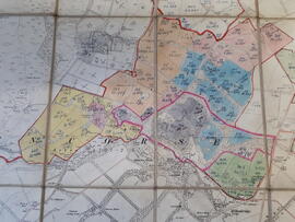
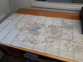
This is a map from 1915 of the "Penicuik Burgh". The survey is from 1852-53 and it was revised in 1905. Handwritten on the first and last page of the map is "BUSH and DRYDEN ESTATES". Inside the map, on the top part of the left hand side it says "Edinburghshire, sheet VII SE" and on the top right hand side "Edinburghshire, sheet VII SE". In the middle of the top part it says "Edition of 1915". Certain areas (belonging to the college) have been coloured in by hand (the colours are pink, blue, grey, green, yellow and orange) and have handwritten numbers added to them. (This could refer to soil profiles and/or previous surveys according to the depositor). These areas have a handwritten red border around them as well as the areas around the hills of Castlelaw and Caerketton in the Pentland Hills that are bordering on to the ground of the Bush Estate. The map is made of paper with a cloth backing and is folded several times. Size folded: 12x8.5 cm, unfolded: 105x88 cm. "Glencorse" and "Lasswade" are typed in bold letters over a large part of the map. Other places clearly seen on the map are Polton, Loanhead, Roslin, Auchendinny and Rosewell.