Identity area
Reference code
Title
Date(s)
- 1915 (Creation)
Level of description
Extent and medium
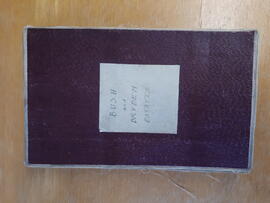
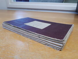
One folded map - 12 x8.5cm (folded) 105 x 88 cm (unfolded)
Context area
Name of creator
Administrative history
The Edinburgh and East of Scotland College of Agriculture (EESCA) was formed in 1901 by representatives of the University of Edinburgh, The Royal Highland and Agricultural Society as well as representatives from a number of regional county councils. It incorporated the University of Edinburgh’s Chair of Agriculture, as well as its existing School of Rural Domestic Economy. Its premises were located in George Square at the University of Edinburgh, which were expanded in 1904. The college carried out the teaching of Agriculture and other allied subjects until 1990 when it was incorporated into SAC (Scottish Agricultural College).
Repository
Archival history
The depositor thinks this map belonged to Donald Mitchell (former college employee of Animal Science, retired around 2014) when he was working "in the old glasshouse block" at Bush. It was found in a desk drawer in an office that had been used by Mitchell. Because the map is very old the depositor thought we might be interested in keeping it in the archive and brought it in himself.
Immediate source of acquisition or transfer
Internal transfer by Robert Redpath to SRUC Archives on 12 March 2019
Content and structure area
Scope and content
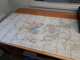
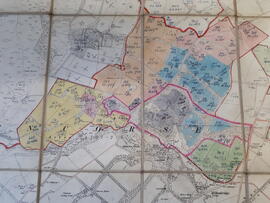
This is a map from 1915 of the "Penicuik Burgh". The survey is from 1852-53 and it was revised in 1905. Handwritten on the first and last page of the map is "BUSH and DRYDEN ESTATES". Inside the map, on the top part of the left hand side it says "Edinburghshire, sheet VII SE" and on the top right hand side "Edinburghshire, sheet VII SE". In the middle of the top part it says "Edition of 1915". Certain areas (belonging to the college) have been coloured in by hand (the colours are pink, blue, grey, green, yellow and orange) and have handwritten numbers added to them. (This could refer to soil profiles and/or previous surveys according to the depositor). These areas have a handwritten red border around them as well as the areas around the hills of Castlelaw and Caerketton in the Pentland Hills that are bordering on to the ground of the Bush Estate. The map is made of paper with a cloth backing and is folded several times. Size folded: 12x8.5 cm, unfolded: 105x88 cm. "Glencorse" and "Lasswade" are typed in bold letters over a large part of the map. Other places clearly seen on the map are Polton, Loanhead, Roslin, Auchendinny and Rosewell.
Accruals
No further accruals expected
System of arrangement
One single item
Conditions of access and use area
Conditions governing access
Conditions governing reproduction
Language of material
- English
Script of material
- Latin
Language and script notes
Physical characteristics and technical requirements
This is a folded map made of paper with a cloth backing. It consists of 27 panels that unfold to a size of 105 x 88 cm. Folded size is 12 x 8.5 cm (also the size of each panel). The map is worn and fragile. The cloth between the panels is ripped and worn away in places. The actual map/paper is still in a fairly good condition and it is still easy to read the writing on it. The map is still very much usable but needs careful handling.
Finding aids
Box list exists
Existence and location of originals
Existence and location of copies
Related units of description
Notes area
Alternative identifier(s)
Access points
Subject access points
Place access points
Name access points
Genre access points
Description control area
Description identifier
Institution identifier
Rules and/or conventions used
Description based on ISAD(G): General International Standard Archival Description, 1999
Status
Level of detail
Dates of creation revision deletion
17 April 2019
Language(s)
- English
Sources
Archivist's note
Martina Sjolund 17 April 2019